What is the definition of land surveying and Why are drones so stable?
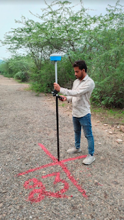
Land surveying is a method of measuring and mapping the physical features of the land, including its shape, boundaries, contours, and location. The process of land surveying has been used for centuries, and it is still an essential tool for a variety of purposes, from designing infrastructure to creating accurate maps and planning urban developments.
In recent years, drones have become increasingly popular as a tool for land surveying. Drone survey in India has grown in popularity in recent years, thanks to the increasing availability of affordable drones, as well as the many benefits that drones offer over traditional land surveying methods.
One of the primary advantages of using drones for land surveying is their stability. Unlike traditional land surveying methods, which require surveyors to physically move around the area being surveyed, drones can be programmed to fly a pre-determined path over the land. This means that the drone can maintain a consistent altitude and speed, resulting in highly accurate and stable measurements.
Another advantage of using drones for land surveying is their ability to cover large areas quickly and efficiently. In the past, surveyors had to walk or drive around the area being surveyed, which could be time-consuming and often resulted in incomplete or inaccurate data. Drones, on the other hand, can cover large areas in a short amount of time, and can even be programmed to fly specific patterns or routes to ensure complete coverage.
In addition to their stability and efficiency, drones are also highly versatile. They can be equipped with a variety of sensors and cameras, which can be used to capture a range of data, including high-resolution images, 3D models, and even thermal imaging data. This means that drones can be used for a variety of purposes, from creating accurate topographic maps to monitoring land use changes and tracking wildlife populations.
Overall, the use of drones for land surveying in India is a rapidly growing trend, thanks to their stability, efficiency, and versatility. As technology continues to advance, it is likely that we will see even more advanced drones and sensors being developed, which will further improve the accuracy and efficiency of land surveying, and enable even more detailed and comprehensive data to be captured.
Business Name- Garud Survey Private Limited
Business Address- 108 MIIC, Near MNIT Campus, JLN Marg, Jaipur, Raj.
Business Number- 7733911999


Comments
Post a Comment